
It plays an essential role in many fields such as air quality improvement, public health, public policy, and urban planning.
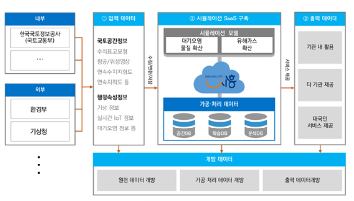
Computational Fluid Dynamics (CFD) techniques were used to accurately analyze the spread of air pollution. The analysis environment was implemented as a SaaS service on a public(LX) digital twin platform to maximize usability and accessibility, and sensor measurement data and simulation data were fused.
Development Scope
- Establishment of SaaS that enables simulation without specialized knowledge by automatically generating mesh and performing simulation
- Automatically generated CAD data of the target site’s topography, architecture, and wind resistance elements near the ground surface
- Integration of weather information to improve accuracy and reliability of results by incorporating real-world weather information into simulations
- Developed a cloud infrastructure design to drive a rendering engine for visualization of three-dimensional simulation results
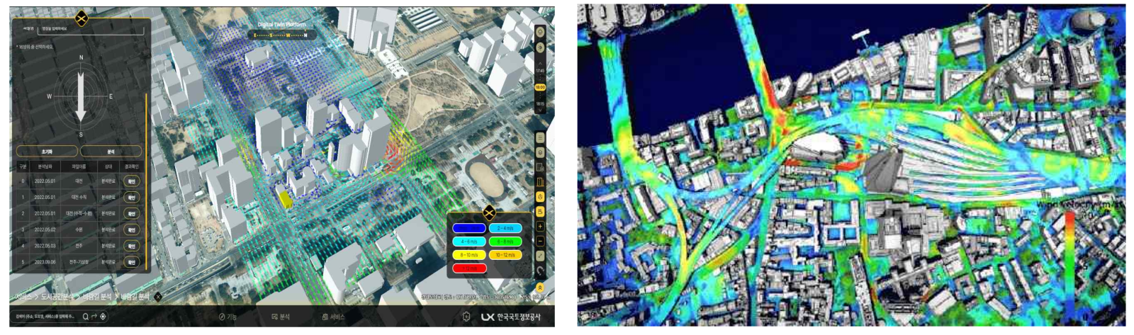
The target site is part of the Sihwa National Industrial Complex (approximately 22.627$km2$) located in Siheung-si, Gyeonggi-do, which is an environmentally vulnerable area such as air pollution.

How it works
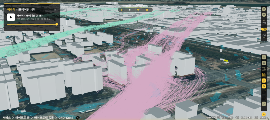
- Predicting the path of fire and air pollutant spread through diffusion simulation, deriving the expected affected areas and providing emergency information in a timely manner
- Linking backtracking simulation with IoT air measurement sensors to track major complex odor generators according to actual measurements
- Utilization of R&D such as data analysis tasks

CFD Simulation Method
CFD Software
The computational fluid dynamics program uses OpenFOAM, a leading open source code. Open source code is ideal for public service platforms because it does not require any license fees, does not limit parallel computations, and can be easily developed and modified to add new features in the future.
The following features have been developed and added to the publicly available OpenFOAM code.
- Atmospheric boundary conditions that account for atmospheric stability – six Pasquill classes implemented from highly unstable to stable
- Ability to simulate pollutant diffusion
- Simulation capability to backtrack pollutant sources from sensor data
- Enhanced solver stability
Automatic geometry and mesh generation using spatial data
The simulator utilizes data on the terrain, buildings, and wind resistance elements near the surface of the target site in the 3D spatial information platform of LX. For this purpose, a module was developed to interface between the format of spatial data used in the platform and the data format used in the simulator.
The terrain data from the topographic maps is converted to an obj file, and the building data is used to create a three-dimensional geometry of the building. This is then used to create a three-dimensional mesh using snappyHexMesh, OpenFOAM’s mesh generation utility. The sequence of steps is performed automatically without user intervention using automated scripts based on the input conditions.

Simulation
Given the actual wind speed, wind direction, and temperature, the files required for the calculation are created and the simulation starts in the cloud. Based on the calculated data, pollutant sensor data is input, and a backtracking simulation is run to estimate the odor source area.
Automatic post-processing
The results of OpenFOAM calculations are automatically generated into images and videos using scripts in ParaView, a three-dimensional data processing program, and converted by the middleware into 3D visualization data for visualization on the digital twin platform.
It is used to automatically generate a report analyzing the scope of pollution spread according to the type and location of the pollution source, and to predict areas that are expected to be affected by the spread of pollutants in advance so that appropriate measures can be taken. The backtracking report creates a list of suspected polluters when sensors detect pollution.

Real Time Simulator
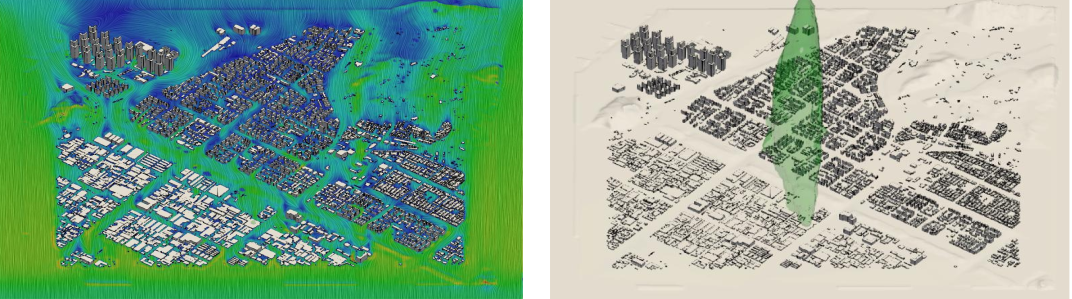
Since computational fluid dynamics is computationally time-consuming, we use simulation data for multiple conditions to create a reduced-order model to obtain data in real time.
Derive experimental points in a given range of wind direction and wind speed, and build a database by simulating each of them. Using the simulation data, perform principal component analysis using the Proper Orthogonal Decomposition (POD) technique and generate a reduced-order model through artificial neural network training. The generated model produces three-dimensional spatial results in seconds with almost the same accuracy as computational fluid dynamics simulations for uncalculated conditions, so simulation results can be obtained in real time by entering only the conditions.
The left side of the figure below shows the result of the computational fluid analysis, and the right side shows the result of the reconstruction by the reduced-order model.

A combination of CFD, digital twin, and SaaS was deployed on a public platform to analyze the spread of air pollution and verify its performance.
Implementing CFD on a digital twin requires automation of the entire process of pre-processing, computation, and post-processing, and development of a real-time simulator using a database. To achieve this, it is essential to use open source code that is easy to develop and automate, can be easily integrated with various programs, and does not require license fees.